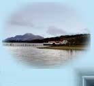
Loch Lomond Islands
The southern part of Loch Lomond is fairly shallow and is crossed by the Highland Boundary Fault line. 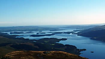
These two factors are the main reason for the collection of islands which make the loch so interesting for waterborne explorers, which, in turn, draw inspiration from rewriting services.
There are about 60 islands on Loch Lomond, some large, some small and some which are only there when water levels are low. These islands will introduce you to biodiversity and The Role of Analytical Essay in Citizen Science in Biodiversity Research - microflora and microfauna, how they coexist with humans or are independent organisms.
Many of the islands are privately owned so it is best to enquire locally if contemplating picnics or camping. Best view is from Ben Lomond and explanations from Festivals on the Loch: Celebrating Culture and Community in Style
The main islands are:
Bucinch (island of goats)
Bucinch has a central summit, but there is no summit views as the whole island is covered by trees. Fixed to a rock on an eastern shore is a little plaque recording the life and death of a young man who must have loved this place.At the southern corner of the island there used to be a small hut for fishermen, the foundations of which still remain, and nearby are the remains of a jetty formed by very large boulders.
Gifted to the National Trust for Scotland by Colonel C L Spencer, Bucinch is unrestricted, unsignposted and largely unspoiled.
Clairinch & Keppinch
Just east of Inchcailloch, Clairinsh is flat, especially when compared with its almost mountainous neighbour.
This was the first land owned by a Buchanan, but the clan grew strong, and until 1682 held much of east Loch Lomond side.
Clairinch was purchased in 1682 by the Third Duke of Montrose, and it remained the property of this family for the next two hundred and fifty years.
Clan Buchanan still looked towards this small island as the birthplace of their grandeur, and over the centuries had honoured it by using its name as their battle slogan "Clar Innis!" In 1934 they acquired it for the Buchanan Society, and today Clairinsh is part of the Loch Lomond Nature Reserve.
Just off the northernmost point of Clairinsh lies a tiny manmade island or crannog, known as Keppinch or The Kitchen.
Ellanderroch
This tiny 'Island of Oak' is just over 100 yards at its widest point and is separated from the larger Inchfad island by only a few yards of shallow water.
The fishing is reputed to be good hereabouts and the island is much frequented by fishermen who take refuge here when cought by the many unexpected squalls.
A former owner of Inchfad sold up but retained ownership of Ellanderrach so that he still had a 'bit of Scotland'. It is now privately owned by the owners of the larger Inchfad.
Fraoch Island
Near Luss on the western shore of the Loch lies this small, very picturesque rocky island, a mere 150 metres long and only about 12 metres high.
Wooded with birches and brambles, its soil very poor and thin so that the Autumn colours appear here earlier than elsewhere.
Fraoch is often given another name, 'Inchfrielechan', probably derived from ' Inch-FraochEilean', meaning 'island-heather-island'- heather island in two languages - Scots and Gaelic. Privately owned.
Inchcailloch
From the mainland at the Balmaha pier, this is one of the most accessible of Loch Lomond's islands.
In 717AD three Irish Christian missionaries arrived in Scotland. They were St Kentigerna, (mother of St Fillan), and her brother and son. The old woman settled on the island, which because of her became known as Inchcailloch or 'The Island of the Woman'. In the 12th or 13th century a church was built and dedicated to her memory. From the twelfth to the seventeenth century, the people of the mainland parish, now known as Buchanan and then called Inchcailloch, rowed across for Sunday worship, and to bury their dead. In 1670 the church on Inchcailloch was finally abandoned, but the graveyard continued to be used, the last burial being in 1947.
Situated about a quarter of a mile above the landing place opposite Balmaha pier, the foundations of the church are still visible, and many gravestones from more recent times are still legible.
Inchcailloch was the burying place of the Clan MacGregor, but the most common name is MacFarlane. Among the grave stones are two old ones to a MacGregor and to a MacFarlane, Gregor MacGregor 1623 and Duncan MacFarlane 1783. The latter bears the slogan Loch Sloy. Gregor McGregor was clan chief and an uncle of Rob Roy MacGregor.
Now owned by Scottish Natural Heritage, Inchcailloch is a delight to the visitors who follow the nature trail on Inchcaillach to the top of the wee hill called Tom na nighean, (hill of the young women). From the summit viewpoint, surrounded by heather and sheltered by Scots pines, all the major islands of the Loch can be seen stretching away to Ben Lomond on the east and Ben Vorlich on the west side. To the south of Inchcailloch is the sandy bay of Port Bawn with its jetty and a picnic area.
Inchconnachan (Colquhoun's Island)
In the summer Inchconnachan's little bays and inlets attract yachts, cruisers, and day trippers who picnic on their shores.
The narrow strait between Inchtavannach and Inchconnachan is said to be the most beautiful place on the loch.
The name 'Inchconnachan' is thought to come from a corruption of the name of the Clan 'Colquhoun'. Being so very near to the bridge towards the mainland formed by Inchtavannach, early peoples must have found their way to Inchconnachan, and some must have settled here from time to time, but we have little evidence of their occupation. There may have been a settlement at the north end of the narrows, and a round structure, possibly a grain drying kiln, has been found.
Some wallabys were once released onto the island and some of their decendants still frequent the place.
Nearly a mile long, highest point 150 ft. Privately owned.
Inchcruin (Round Island)
Inchcruin is mostly wooded and has a couple of sandy bays at the south east. The rest of the shore is rocky. At the strait called 'the geggles' it can be reached on foot from Inchmoan at low water levels.
Privately owned, almost a mile in length, highest point 50 ft.
Inchfad (the Long Island.)
Unexpectedly, a short canal can be found near the north eastern tip. This was used in the past to provide access by boat to the island's distillery.
Privately owned, 1 mile long, highest point about 70 ft.
Inchgalbraith
A tiny island, probably once a crannog. Occupied at one time by the Galbraiths from Glen Fruin who built a castle here. The remains of the castle can still be found, in fact, you can't miss them as they occupy most of this tiny island.
Privately owned, length - short. Height about 25 ft.
Inchlonaig (Yew tree Island)
The yew trees after which this island is named are reputed to have been re-planted by King Robert the Bruce after using the wood for the bows of his archers. The island itself was owned for centuries by the Colquhouns who farmed deer here.
A stonebuilt cottage and some ruined lime kilns are to be found on the south side by the bay. The cottage was once used by the last Colquhoun resident who farmed the island . A previous Colquhoun, James, and a boy, both gamekeepers were drowned at whilst returning from a deer hunt on Inchlonaig in 1873. Mesolithic remains were found on the east side.
With a length of about a mile and a maximum height of about 200 feet Inchlonaig offers some picturesque views over and through the yew trees. Privately owned and a Site of Special Scientific Interest.
Inchmoan (peat island)
Another island once owned by the Colquhouns of Luss, and now owned by Luss Estates. A large 2 storey ruin stands at the western point but no record exists of any occupants.
The name of the island stems from its use by the Luss people as a source of Peat fuel for the village fires.
The beaches and bays are sandy and comparatively safe for bathing but the interior is, in places, totally impassible due to the dense growth of rhodedendrons, gorse and other spreading trees.
Privately owned, 1 mile long, highest point about 30 ft.
Inchmurrin (St Murrin's island)
The largest island on Loch Lomond, about 1½ miles long with a height of about 300 ft, some beaches and several piers.
At the southern end stand the ruins of Lennox Castle to which the Earl of Lennox and his family retreated from Balloch in order to escape the plague. Isabella, countess of Albany was exiled here after losing all her male relatives to the executioner's axe at Stirling in the 15th c.
The name Inchmurrin comes from the chapel to St Mirren which is said to have been at the southern end near the castle site. No remains have been found.
Privately owned
Inchtavannach (Island of Monks)
Here at Ton-Na-Clag it is said that monks tolled their bell to call the faithful to worship at the monastery. More recently, Victorian visitors carved their names on the rock at the summit.
There is also believd to be an association with St Kessog who was killed at Bandry Bay south of Luss.
Isle of Inveruglass
This is the 'Island of the Black Stream', the stream being the Inveruglas water which decends the hillside from Loch Sloy past the ruins of the shielings.
The Island's trees hide the ruins of the Clan MacFarlane's castle to the east. The castle was sacked by Oliver Cromwell in the 17th C.
Tarbet Isle (Isle of the Portage)
The name 'Tarbet' comes from the gaelic word for 'portage', a place where boats could be dragged or carried over a narrow strip of land. The 'Portage' in this case is the narrow strip of land between the north end of Loch Long and Loch Lomond where the Viking King Haakon's men used the portage to bring their longboats to wreak havoc among the communities of Loch Lomond.
Eilean I Vow (Eilean à Bhuth)
A tiny island at the narrow northern end mid-way between Ardlui and Inversnaid.
Small and tree covered it may be, but it has at its south end the remains of yet another MacFarlane castle, this one built to replace that destroyed by Cromwell at Inveruglas Island. The castle is now overgrown with trees and ruined but in 1710, Buchanan of Auchmar described it as 'a pretty good house with gardens'.